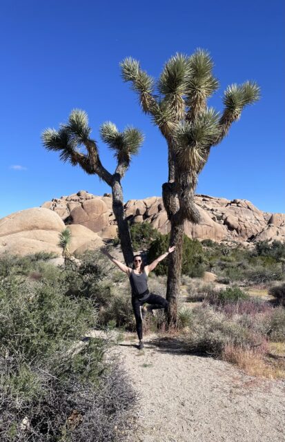
Joshua Tree National Park Itinerary
If you want a well-rounded guide to Joshua Tree National Park complete with elevated views, a little workout, instagramable rock formations and native desert plants, this one day itinerary is for you.
This is the itinerary my husband and I used for our own trip to Joshua Tree when we lived in Palm Springs (If you want more about Palm Springs, check out this post: Living in Palm Springs for Three Months)
We spent around 6 hours in the park, but you can easily add more time by stopping at various additional points along the same path. These additional points are fairly well marked throughout the park, so you can easily choose to include them or not as you go.
Here are all the stops for this adventure:
- Keys View
- Ryan Mountain
- Famous Rock Formations- Skull Rock, Heart Rock and Arch Rock
- Cholla Cactus Garden
But first, there are a few things you should know before starting your visit to Joshua Tree National Park. For example, there is little to no cell reception in the park, so you’ll need to plan ahead.
Important Things to Know
Getting There:
There are 3 main park entrances
- West Entrance (Joshua Tree Village)
- North Entrance (Twenty-Nine Palms)
- South Entrance (Cottonwood entrance, off I-10, east of Indio)
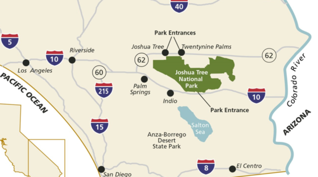
The West entrance starts you on Park Boulevard which is the main scenic road from which we based most of our stops. The South Entrance is accessed by Pinto Basin Road, also named Cottonwood Springs Road. North entrance takes you to Utah Trail, which then connects to both Park Boulevard and Pinto Basin Road. Here is a graphic to make this a little more clear:

For this itinerary, we started at the West Entrance and ended at the South Entrance, but it would be easy to hit most of these stops even if you have a different start and end point.
Costs
Park entry is $30 per vehicle (alternatively, get the America the Beautiful Pass for access to all national parks and many other federal recreation sites for a full year for $80).
When to Visit
We visited Joshua Tree in October which gave us really nice weather. In case you are visiting at another time of year, here is some information on what temperatures to expect:
- Fall and Spring (the most popular seasons)
- 70s-low 90s Fahrenheit during the day
- 40s-60s at night
- Winter (also a good time to visit, but it can get cold at night)
- 50s-60s Fahrenheit during the day
- 30s-40s at night
- Summer
- over 100 degrees during the day (there is also not very much shade available) – if you must go in the summer, bring a lot of water, wear sun protection and keep your hikes short.
Joshua Tree National Park Itinerary
Stop 1- Sunrise at Keys View

To get to Keys View, take Park Boulevard (aka loop road) from the West entrance. After 10 miles on Park Boulevard, take a right onto Keys View road. You will run into the Keys view parking lot at the end of Keys View Road. The drive from the West entrance to the parking lot takes about 30 minutes.
There is a short walking path here (0.1 mile) with panoramic views of Coachella valley, the Salton Sea, the San Gorgonio mountains and more.
The desert can be cold when the sun isn’t out, and Keys View tends to be windy, so bring a jacket and a windbreaker.
If you aren’t up for an early morning, you can totally go to Keys View later in the day. However, if you can get yourself up this early, the views are stunning!
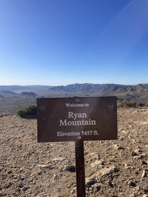
Stop 2- Ryan Mountain
- 3 miles round trip
- Over 1000ft elevation gain
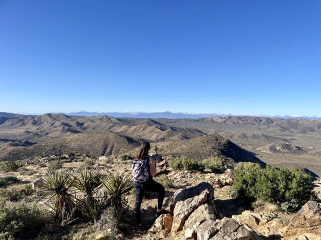
Next up is Ryan Mountain, the best hike in Joshua Tree National Park (in my opinion). It is also our only true hike with significant elevation gain in this itinerary.
The timing after the sunrise at Keys View was perfect as the exercise warmed us up during the hike, and the sun had warmed up the park by the time we were finished.
To get to Ryan Mountain, get back on Keys Road (the same way you came in), then take a right onto Park Boulevard. The trailhead for Ryan Mountain trail will be on your right. It’s a 20 minute ride from Keys View. There is a large parking lot and restrooms here as well.
Even though this is a relatively short hike, some sources consider it to be difficult due to the elevation gain. Personally, I would label it as moderate. There are great views all the way up the trail, so it is definitely worth the climb!
Stop 3- Famous Rock Formations
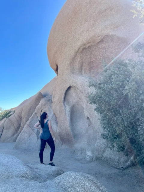
There are several cool looking rock formations throughout the park. We chose to stop at the big 3: Skull Rock, Arch Rock and Heart Rock. However, you will see several others (such as Cap Rock or Split Rock) that you can add into your itinerary if time allows. Drive slow and look for signs. They will be pretty easy to find.
To get to our first rock formation, Skull Rock, get back onto Park Boulevard and continue to the right, you will come across the parking lot for Jumbo Rocks after about 5 miles (we didn’t stop here, but it is an example of the well marked points of interest/trails throughout the park). Just past the Jumbo Rocks parking lot is the famous Skull Rock. You will likely see other park visitors lined up to take photos next to Skull Rock. There is a little bit of shoulder to the road here, so you can park almost right next to it.
If you continue past Skull Rock on Park Boulevard for a few more miles, you will come to a split in the road. Take the right onto Pinto Basin Road (also referred to as Cottonwood Springs Road) and continue a few miles to the Twin Tanks/Arch Trail parking lot. There is a small trail that will take you across the street from the parking lot to Arch Rock Trail.
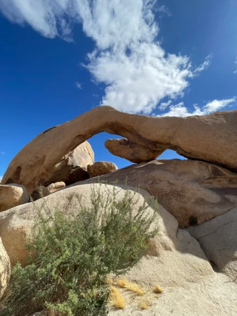
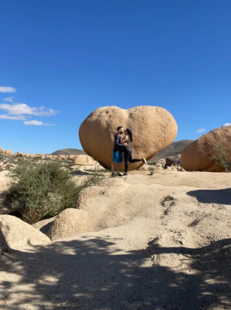
Arch rock trail takes you to both our other famous rock formations- Arch Rock and Heart Rock. It is a relatively flat, easy walk and about 1.5 miles total to see both rocks.
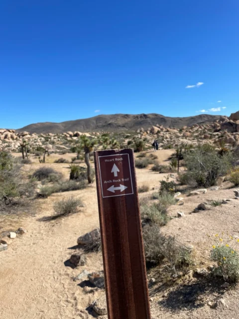
You may see some older travel logs that mention going off trail to find Heart Rock, but this is no longer the case as there is now a well marked trail to Heart Rock that branches off of the Arch Rock Trail (as you can see, the above map doesn’t show heart rock trail, but you will pass the sign if you follow Arch Rock Trail.
Here is the sign you are looking for to find Heart Rock:
After seeing Heart Rock, we continued back to the Arch Rock Trail which led us to the formation pretty quickly. We walked around off the trail a bit here and did some rock scrambling. It’s a really cool looking area, but be careful to note your surroundings as it’s easy to get lost.
Stop 4- Cholla Cactus Garden
For the last stop on our journey, we chose Cholla Cactus Garden. This added a little more variety to round out our visit.
To get to Cholla Cactus Garden, take a right back onto Pinto Basin Road/Cottonwood Road for about 8 miles until you reach the Cholla Garden Nature trail parking lot.
This is another easy, flat trail and is 1/4th of a mile. This easy trail can actually be a bit treacherous due to the cholla or “teddy bear” cacti. Even slightly brushing against one of these will leave you with painful barbs to remove. The field of these funky looking cacti looks really interesting with the mountains in the backdrop.

If you haven’t had enough desert plants for one day, there is another stop for the Ocotillo patch a little further down Pinto Basin road that you can add to your itinerary.
Exiting the Park
To exit the park, you can either go back the way you came on Pinto Basin Road turning onto park boulevard to get back to the West Entrance or you can continue straight onto Utah trail to the North Entrance where you will exit to the city of Twenty-Nine Palms just a bit further down HWY 62 from where the day started. My husband and I were headed back to Palm Springs, so we continued further down Pinto Basin/ Cottonwood Springs Road to the South Entrance.
I hope you enjoy this Joshua Tree National Park itinerary! Comment below with your favorite stops in the park.
Want more hiking nearby? Check out the hikes in this guide to the Palm Springs Aerial Tramway: Palm Springs Aerial Tramway Hiking.
Looking for more outdoor adventure itineraries in Southern California? Check out this itinerary for a dog friendly trip to Big Bear.

Julie (Juls for short) is the founder of travelingwithjuls.com. She is a registered nurse turned travel nurse. She loves adventure and learning about new places. Her goals are to help other nurses learn about travel nursing, and to share information about the locations/destinations she lives in for 3+ months at a time.


