Palm Springs Aerial Tramway Hiking
Hiking at the Palm Springs Aerial Tramway is a must do activity for anyone visiting the area. The Tramway is rated as one of Palm Springs most popular attractions and a favorite of both locals and tourists.
At the time of writing this, I have been in Palm Springs for around 1.5 months. Every time someone finds out that I am new to the area, they ask if have been to the Aerial Tramway yet. Here are a couple of things that I have learned so far:
- The Peak’s restaurant (at the top tram station) is a favorite for special occasions. I recently met a man who just celebrated his 92nd birthday at this restaurant.
- Hiking to the peak of San Jacinto earns you bragging rights. I have had at least three people proudly tell me that they once hiked to the peak.
If you visit in the summer, the cooler air at the top of the Aerial Tramway is a much welcomed reprieve from the heat of the desert below. The temperature change compared to Palm Springs is around 30-40 degrees cooler. The difference in climate is pretty amazing!
Keep reading for information on costs, what to expect, and hiking trails.

Tickets and Costs:
You can purchase tickets on the Aerial tramway website here or in person at the valley station. We went in September 2023 and it costs $31 each for our tram tickets.
Parking costs money as well (card or cash accepted). It was $15 at the time we went, but prices can vary.
In addition to your parking pass and tram ticket, some of the hikes at the top require a permit- don’t worry, the permit is free unless you plan on camping.
What to Expect:
After you park at the tram station, go inside to purchase your tickets (if you did not purchase online ahead of time).
There is a small restaurant inside, but I recommend going to the other restaurant at the top which is nicer (you may need a reservation on a busy day). Inside the tram station, you will also find a little history about the area, restrooms, and the ticket counters.
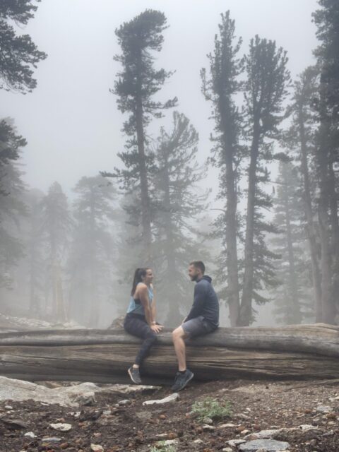
The ticket counters have signage regarding the weather at the top. Pay attention to the weather signs. The day that my husband and I went, the weather was cloudy with a chance of thunderstorms which limited both visibility and our ability to hike to the peak as we originally intended. The fog did, however, look really pretty between the trees during the hike.
The tram station will announce overhead when it is time to board the tram. The tram travels up the mountain slowly and rotates giving you a 360 degree view all the way up (another reason to choose a day with good visibility).
Once you get to the top tram station, you will have access to several viewing decks (over 8500 feet of elevation!), a cafeteria, Peaks Restaurant that I mentioned earlier (it has a bar too), a gift shop, and a couple of help desks. To get the the hiking trails, go to the bottom level and out the door that is across from the lockers.

Palm Springs Aerial Tramway Hiking Trails:
Wellmans Divide
This is the hike my husband and I chose as we were unable to hike to the San Jacinto Peak due to weather. The trail starts as part of the Round Valley Loop trail and continues on after the Wellmans Divide lookout to the San Jacinto Peak. This section of the hike includes a 600ft elevation gain. It’s well marked and easy to follow. We were not able to see very much of the view at the lookout due to fog, but it is supposed to be pretty impressive.
Distance: Roughly 6 miles round trip- (start on the Round Valley Trail)
Difficulty: moderate to strenuous
Permit required: just stop by the ranger station which is along the trail
San Jacinto Peak
This is the part of the trail that continues on after Wellmans Divide. I’ve been told that the trail gets a bit easier after Wellmans Divide, but the overall elevation (over 10,000 feet) can cause problems for some people.
If you start experience symptoms of altitude sickness, such as nausea and headache, it is time to turn around and get to a lower elevation.
One more thing to note if you plan to hike to the San Jacinto Peak- brings lots of water. The rangers will ask, and they recommend at least 2 liters per person.
Distance: 11 miles round trip
Difficulty: Strenuous
Permit required
Round Valley
This is the beginning of both the Wellmans Divide and the San Jacinto Peak trails. It’s fairly level with some short climbs.
Distance: 4.3 mile loop
Difficulty: moderate
Permit required
Desert View
This trail offers several view points if you are looking for something without too much elevation gain, but still with pretty lookouts.
Distance: 1.5 mile loop
Difficulty: easy to moderate
No permit requirement
Long Valley Discovery
Explore the different flora and fauna compared to the desert below on this easy loop trail.
Distance: 0.75 mile loop
Difficulty: easy
No permit requirement

Looking for more to do in Palm Springs?
Check out this post for a hike to a waterfall in Palm Springs, or this one for a dog friendly day trip outside of Palm Springs.
I hope you enjoyed this post about the Palm Springs Aerial Tramway hiking trails! Comment below with your favorite Southern California hikes!